

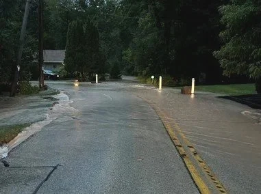
When historic flooding hit the Village of Fox Point, staff faced a familiar but urgent challenge: collecting and organizing data quickly enough to support emergency response efforts. Homes were damaged, streets were underwater, and the information needed to be compiled fast for Wisconsin Emergency Management (WEM). The traditional approach—manually gathering photos, mapping locations, and tracking assessments—was slow and labor-intensive.


This matters because delays in data collection can affect funding, recovery timelines, and long-term planning. Communities need accurate, real-time information to respond effectively and advocate for resources.
To meet this challenge, R/M’s GIS (Geographic Information Systems) team used an ESRI Suite of tools, featuring an Experience Builder web application that allowed the aggregation of both spatial and informational materials which included:
Mapped flooded areas
Linked photos to exact locations
Tracked affected homes
Compiled assessments required for WEM


This approach saved hours of manual work and gave emergency managers a clear, organized view of the situation which helped them respond faster and more effectively. Scott Brandmeier, Fox Point’s Director of Public Works, shares his thoughts about the project:
“Ruekert & Mielke’s team is always responsive to the ideas I have floating around in my head and applying those ideas to a practical application within ArcGIS. The maps created always help tell the story much better than words alone and often tell more than one story. In this case, the maps identified the extent of the flooding and will likely assist us in our questioning of the floodplain before regulatory and elected bodies.”
A similar situation in the City of Mequon showed why accurate local data is essential. Residents were added to FEMA’s expanded floodplain maps and required to purchase costly flood insurance, with some paying up to $3,900 per year. After historic flooding, many found that the water never reached their homes. The City of Mequon discovered FEMA’s data had overestimated river flow rates, and is now working to revise the maps. This underscores the value of community-driven, location-specific data like what was collected in the Village of Fox Point.
The Village of Fox Point’s experience demonstrates how empowering Public Works staff through the use of GIS can transform emergency response. By involving the community and centralizing data, R/M not only improved response time but also laid the groundwork for better long-term planning.
NEXT STEPS
R/M is ready to support other communities in preparing similar tools. By setting up surveys in advance and leveraging GIS technology, we can help municipalities respond more efficiently and advocate more effectively during future disasters.
About the Author

Tim Andserson
GIS TEAM LEADER
Tim serves as a Team Leader, Project Manager, and Customer Success Manager for municipal clients. He manages several multi-discipline GIS analysts through his role as the GIS Team Leader. He has assisted R/M in several technological advances throughout his career including eFieldReporting, AutoCAD Civil 3D, AssetAlly, as well as the direction and leadership of our latest web-based GIS solutions. He operates as a partner and advisor who helps communities refine and enhance GIS business processes.